
The Nymboida River rises in the northern foothills of the Barren Mountain, on the slopes of the Great Dividing Range, within Bellinger River National Park, west of Dorrigo.
The river flows in a meandering course generally northeast, joined by nine tributaries including the Little Murray, Bielsdown, Blicks, Little Nymboida, and Boyd rivers, before reaching its confluence with the Mann River, below Mount Gundahl, within the Nymboida National Park.
The river descends 1,250 metres over its 165-kilometre course.
[source: Wikipedia]
Get on the river!

We offer several different drop-off and pick-up locations to facilitate single day or overnight trips.
The river offers great paddles for all levels of experience. Explore the river with our professional guides or hire the equipment from us and create your own river experience (subject to your experience level and river height) .
Call the office to discuss the best option for you.
The river experience is dependent on river levels, so call the office for further information.
Refer to the Clarence Valley Canoe and Kayak Trail for maps and further information
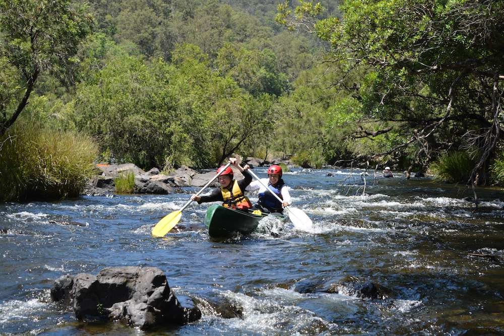
Guided River Trips
We offer various length canoe or kayak trips with fully qualified guides.
Before your adventure begins your guide will deliver a full safety briefing. You will be provided with the necessary safety equipment, including a personal flotation device (PFD) and helmet.
Then we head off on your white water adventure.
Flat Water Paddling Experiences
Known mainly for its whitewater, Nymboida Canoe Centre also serves as an ideal hub for exploring flat water paddling rivers. All of these below make a leisurely day trip. If you have your own boat or roof racks these might be for you.
No shuttles available for these trips
All of these paddles are two way - meaning you can generally leave your car in one spot and paddle up or down river and then return to your vehicle. If you choose to paddle around the high tide time you will not experience any strong tidal currents. The further up river you are, the less the tides will impact your paddle.
Coastal River Paddles
Wooli River: 65 mins. Fishing, Tidal (check tide times)
Corindi Creek: 65 mins. Sections are part of the Marine National Park. Fishing permitted in some sections - clear signage. Tidal (check tide times)
Esk River Launch: 70 mins
Paddle through Bundjalung National Park - Paddle up river or down river.
29° 21' 13.1256" S 153° 19' 4.6452" E
Everlasting Swamp National Park : 65 mins.
Excellent bird watching. You can launch the weir, but it can be muddy or go through the National Park gate and look for a spot to launch nearby. This is a great paddle, but water entry is a bit of a challenge - be prepared to get a bit muddy.
Hinterland Flatwater Paddles
Clarence River - Large sections of the Clarence River are accessible for interesting paddling. Fishing in all areas. Tidal with a variety of scenery.
Below are a number of boat ramps in the area that present different paddling experiences.
Keep in mind that the Clarence has some very broad sections making paddling in strong winds in these locations dangerous. Check the forecast wind speeds.
Ulmarra 40 mins.
Explore up or down river. Interesting little town with bookshop, craft and riverside dining at the Ulmarra Pub
Prince St Grafton 35 mins.
Paddle from the end of Grafton’s main street - paddle around Susan Island or simply explore up or down river.
Cowper Boat Ramp 45 Mins.
Explore up or down river.
Clarence River - Orara River Confluence :44 Mins.
Eatonsville
The Orara river runs into the Clarence River 2.5 kms north of the launch spot (A higher clearance car can be helpful here - the quality of the launch area can be affected by floods.)
Paddle upriver on the Clarence - Interesting rock formations and grazing land - turn west up the Orara for some interesting native vegetation. Birds and fishing